
Land Acknowledgement
Friends of the Forest acknowledges that we gather on the ancestral lands of the Wangunk, an Eastern Algonquin indigenous people, known as the people at the bend in the river, who were removed unjustly, and that we in this community are the beneficiaries of that removal. We honor them, and we pay respect to elders, both past and present.
We remember, with reverence, these indigenous people who stewarded this beautiful landscape for thousands of years.
We are grateful for the River, the Majestic Trees, the Rolling Hills, Coyotes, Red-Tailed Hawks, Deer, Bald Eagles, and all other
beings with whom we share these lands.
We also acknowledge that all land in the State of Connecticut was once Native territory. This is the land of the Mohegan, Mashantucket Pequot, Eastern Pequot, Schaghticoke, Golden Hill Paugussett, Nipmuc, and Lenape Peoples, who have and continue to steward this land throughout the generations. We thank them for their strength and resilience in protecting this land and aspire to uphold our responsibilities according to their example.
Connecticut law recognizes five Indian tribes: (1) Golden Hill Paugussett, (2) Mashantucket Pequot, (3) Mohegan, (4) Paucatuck Eastern Pequot, and (5) Schaghticoke. These five tribes have six reservations in the state.
Why Do We Recognize the Land?
To recognize the land is an expression of gratitude and appreciation to those whose territory you reside on, and a way of honoring the Indigenous people who have been living and working on the land from time immemorial. It is important to understand the long-standing history that has brought you to reside on the land and to seek to understand your place within that history. Land acknowledgments do not exist in a past tense or historical context: colonialism is a current ongoing process, and we need to build our mindfulness of our present participation. It is also worth noting that acknowledging the land is Indigenous protocol.
What is a Land Acknowledgment?
A Land Acknowledgment is a formal statement that recognizes and respects Indigenous Peoples as traditional stewards of this land and the enduring relationship that exists between Indigenous Peoples and their traditional territories.

The Wangunk Indian Tribe
The Wangunk people were part of the Eastern Algonquin indigenous people who lived along both sides of the southern span of the “long tidal river” (Quinnitukqut) in present-day Middletown and Portland, Connecticut, while their traditional territory reached as far north as Wethersfield and Chatham, Connecticut. Although regarded as "extinct" by settlers in the aftermath of King Philip's War, 1675-1678, the Wangunk continue to live into the 21st century.
Archaeological surveys have uncovered hundreds of Native American sites in Connecticut. Many of them were located in the Connecticut River Valley, which was the center of the Wangunk homelands (Office of State Archaeology ND). Over a dozen Paleo-Indian fluted points have been recovered from sites within these Wangunk homelands (Bouchard 2014). Postcolonial Wangunk communities are frequently mentioned in the Public Records of Connecticut and various town records, as well as other European documents. The Wangunk tribe held claim to a huge swath of territory, and that territory was occupied by a substantial indigenous population continuously from PaleoIndian times well into the contact period.
By the time of European settlement in 1633, over a dozen Wangunk villages were known to be located along the river: Poquonnoc (present Windsor Locks); Suckiog (present Hartford); Matianuck and Mattacomacok (present Windsor); Pyquag (present Wethersfield); Nayaug and Naubuc (present Glastonbury); Wangunk (present Portland); Mattabesek (Middletown); Coginchaug (present Durham); Cockaponset (present Haddam); Cossonnacock (present Haddam/Lyme area); south to Pattyquonk & Machemoodus (East Haddam) (Ives 2001, 2004; Yale Indian Papers 2015).
Archaeological findings demonstrate that pre-Colonial Wangunk technology, economy and settlement systems were complex (e.g., McBride 1984; Lavin 2013). So were their socio-political systems. Insight into pre-colonial Wangunk politics is provided by early Dutch and English documents that demonstrated a strong central Wangunk government residing in the grand sachem Sowheag and his sons and other kin, who were sachems of the various Wangunk villages (Yale Indian Papers Project, accessed 2015).
Wangunk land transactions demonstrate other social complexities (Ives 2001, 2004 ). Pre-colonial Wangunk military might is indicated by the tribe’s willingness to confront the powerful and fearsome Pequots in their drive to control the incipient fur trade in the lower Connecticut Valley at the beginning of the 17th century. Dutch records show that the two tribes fought three major battles (Yale Indian Papers Project, op. cit.).
Wangunk cultural sophistication is demonstrated through their artwork and spiritual symbols. Wangunk cooking pots are often embellished with incised or impressed designs representing the spirits of the four directions (or six directions – north, south, east, west of the middle world or earth, the underworld, and upper world) and linear rows of impressed dots representing the Trail of Life or Beautiful Path.
The Wangunk were not a simple, primitive people. Rather, they were an economically successful, complex, sophisticated society with extensive knowledge of their physical and social environments.
European settlement and the subsequent introduction of European diseases; destruction of indigenous economies due to land losses, European farming techniques, and industry; loss of Wangunk males recruited to serve in AngloAmerican wars; and the ensuing impoverishment and discrimination brought an end to Wangunk political power and economic success. Yet the continuous presence of Wangunk descendants within their ancient homelands to this very day is a testament to the endurance of Wangunk community life.
Excerpt from Pre-colonial History of the Wangunk, Lucianne Lavin, Ph.D. Institute for American Indian Studies Presented at the panel event “Indigenous Middletown: Settler Colonial and Wangunk Tribal History” December 5, 2015 at Wesleyan University, Middletown, Connecticut
Name Variants: Wongunk, Wongum, Mattabesett, Pyquag, River Indians, Middletown Indians, Sequins
Meaning: The people at the bend in the river
Tribal Associations: Podunk, Suckiag, Podunk, Tunxis, Mohegan, Quinnipiac, New Hartford, Brothertown
Location: Middlesex County west of the Connecticut River in present-day Cromwell, Durham, Haddam, Middletown, Wethersfield, and east of the Connecticut River in East Haddam, East Hampton, Glastonbury, and Portland (Chatham)
Villages: Cockaponset, Coginchaug, Cossonnacock, Hockanum, Machamoodus, Mattabesec, Mattacomacok, Naubuc, Pocowset, Pyquag, Suckiog
Leadership: Sowheage (d.c. 1649), Turramuggas (d.c 1705), Peetoosoh, Cushoy (c. 1685-1763), Tom Cushoy (d. 1755)

Remember their Voices
“For countless generations, Mamoosan’s (“Son of the Moose”) people, the Wangunks, had thrived here in a place they called Mattabeseck. But now, in the 1740s, Mamoosan was among the handful of his people that remained. He surveyed what little was left of their vast ancestral lands and despaired. His people were destitute. Younger Wangunks, in search of a better life, had set off to join settlements of related Native Americans in northern New York. Reluctantly, Mamoosan, then 40, followed.
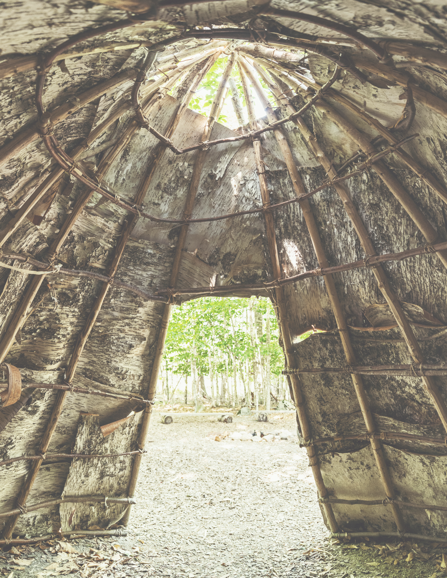
Before the 1600s, the Algonquin-speaking Wangunks had dominated this area of Connecticut for centuries. They were spiritual people who revered Manitou, the Great Spirit found in all living things and in the forces of nature. They made tools from stones and animal bones, cured animal hides for clothing, and carved canoes out of birch. Round-topped wigwams gave them shelter; game and fish fed them. They planted crops of corn, squash, and sunflowers.
But the arrival of Europeans brought the beginning of the end of their way of life. Smallpox and other epidemics decimated Connecticut’s native peoples, who had no natural immunity to such diseases.
When English families arrived in Connecticut, Sowheag, the Wangunks’ leader, sold large tracts of land to the colony, retaining two sections for his people: one on the east side of the Connecticut River, in what is now Portland, and another on the west side of the river stretching from today’s Newfield area to Indian Hill. On this promontory, Sowheag had built a fortification from which he could survey his domain.
In some parts of New England, hostilities erupted into brutal battles between the native people and the English settlers. In 1675 the bloody conflicts that characterized King Philip’s War destroyed many English settlements, but the impact on the native population was catastrophic. Large numbers were killed or driven away as refugees; others eventually retreated into small reservations.
The settlers’ rule grew stronger, and the Wangunks’ numbers grew fewer as they sold off more pieces of their ancestral lands and moved away.
By the 1740s, when Mamoosan left his homeland to settle in New York State, only a remnant of his people remained. Many of them married into local African-American families; today, some of their descendants still live in the community. Others died here, destitute and alone, their lands gone and heritage nearly forgotten.”
What You Can Do
Land acknowledgment alone is not enough. It’s merely a starting point. Ask yourself: how do I plan to take action to support Indigenous communities? Some examples of ways to take action:
Support Indigenous organizations by donating your time and/or money.
Support Indigenous-led grassroots change movements and campaigns. Encourage others to do so.
Commit to returning land. Local, state, and federal governments around the world are currently returning land to Indigenous people. Individuals are returning their land, too. Research your options to return your land.
Resources
Wangunk Bibliography
R. W. Bacon, “Native Americans in Middletown: Who called it ‘home’ before our ‘First Settlers’?, Middlesex County Historical Society, The Middler, Newsletter of the Society of Middletown First Settlers Descendants, Part I (vol. 10:1, Spring 2010), Part II (vol. 10, no 2) Fall 2010.
The Bridge, "The Wangunk Native Americans of Middletown" (October 2010).
Karen Cody Cooper, “They Have Seized Upon Our Country: The Wangunk of Wethersfield, Artifacts 14 (2): 4-8.
Eliot Gray Fisher, Last of the Wangunks.
Katherine Hermes, “’By their desire recorded’: Native American Wills and Estate Papers in Colonial Connecticut,” Connecticut History, vol. 38, no. 2 (Fall, 1999), 150-173.
Timothy Ives, “Reconstructing the Wangunk Reservation land System: A Case Study of Native and Colonial Likeness in Central Connecticut,” Ethnohistory 58 (1): 65-89.
Timothy Ives, Wangunk Ethnohistory: A Case Study of a Connecticut River Indian Community (Ph.D. Dissertation, College of William and Mary, 2001).
Timothy Ives, “Expressions of Community: Reconstructing Native Identity in Seventeenth-Century Central Connecticut Through land Deed Shirley W. Dunn, ed., Mohican Seminar 3: The Journey—An Algonquian Peoples Seminar (Albany, 2009), 25-68.
Sarah Schneider Kavanagh, "Educating a New American Citizenry at Indian Hill Cemetery," in Colleen E. Boyd and Coll Thrush, eds., Phantom Past, Indigenous Presence: Native Ghosts in North American Culture & History (Lincoln, NE: 2011).
Middlesex County Historical Society, “Wangunks: Their Own Stories: Voices from Middletown’s Melting Pot.”
Carl F. Price, Yankee Township (East Hampton, CT, 1941).
Doris Sherrow, “What Happened to the Wangunk?,” Portland, On the Move (Portland, CT, 1999).
Doris Sherrow, “Who Were the Wangunk?,” Portland, On the Move (Portland, CT 1999).
References Cited
Binzen, Timothy L. 1997 Mohican Lands and Colonial Corners: Weataug, Wechquadnach and the Connecticut Colony 1675-1750. Unpublished MA thesis, Department of Anthropology, University of Connecticut at Storrs. 3 2009. “The River beyond the Mountains: Native American Settlements of the Upper Housatonic during the Woodland Period.” In Mohican Seminar 2, The Challenge—An Algonquian Peoples Seminar, ed. Shirley W. Dunn, pp. 7-17. New York State Museum Bulletin 506.
Bouchard, Michael 2014 The Paleo Project: A Review and Interpretation of Paleo-Indian /site distribution Patterns in Connecticut…Asking the Questions Thirty Years after Templeton. Bulletin of the Archaeological Society of Connecticut 76:5-32.
Colley, Brent ND Indian Trails in and around Redding, Connecticut & Georgetown, Connecticut, and his power point presentation, The Influence American Indian Pathways had on Connecticut Transportation Systems & Settlements. Web site accessed December, 2015; http://historyofredding.net/ HRindians.htm. Crone-Morange, Paulette and Lucianne Lavin 2004 The Schaghticoke Tribe and English Law: A Study of Community Survival. Connecticut History 43(2):132-162.
Ives, Timothy H. 2001 “Wangunk Ethnohistory: A Case Study of a Connecticut River Indian Community”. M.A. Thesis, Department of Anthropology, William and Mary College, Williamsburg, VA. 2004 “Expressions of Community: Reconstructing Native Identity in Seventeenth Century Central Connecticut through Land Deed Analysis.” paper presented at the Fifth Annual Algonquian Peoples’ Conference, March 14, 2004, Albany; later published in 2009 in Mohican Seminar III: The Journey An Algonquian Peoples Seminar, ed. Shirley W. Dunn. New York State Museum, Bulletin 511. Lavin, Lucianne 2013 Connecticut’s Indigenous Peoples: What Archaeology, History, and Oral Traditions Teach Us about their Communities and Cultures. Yale University Press, New Haven and London.
McBride, Kevin A. 1984 The Prehistory of the Lower Connecticut Valley. Ann Arbor, MI: University Microfilms International. Dissertations Collection for the University of Connecticut, Paper AAI8509510, http://digitalcommons.uconn.edu/dissertations/AAI8509510.
Moeller, Roger W. 1980 6LF21: A Paleo-Indian Site in Western Connecticut. American Indian Archaeological Institute, Washington, CT. Office of State Archaeology (OSA) ND Site Files for archaeological sites in Connecticut are located in the OSA at the University of Connecticut in Storrs, CT.
Spiess, Matthias, and Hayden L. Griswold 1930 Map of Connecticut, Circa 1625, Indian Trails, Villages, Sachemdoms. Compiled by Mathias Spiess and drawn by Hayden L. Griswold, C.E. Published by the Colonial Dames of America Connecticut Society. 4 Yale Indian Papers Project 2015 Web site accessed in November and December, 2015; http://yipp.yale.edu/.